


Rediscovering Kequasangansett 3
Possible Sacred Stone and Water Works Around Gates Pond in Berlin, Massachusetts

Part Three in a series — read Part One Here and Part Two Here.
Partial History of A Place
Once known as Kequasagansett, this area now bears the names of those who came later.
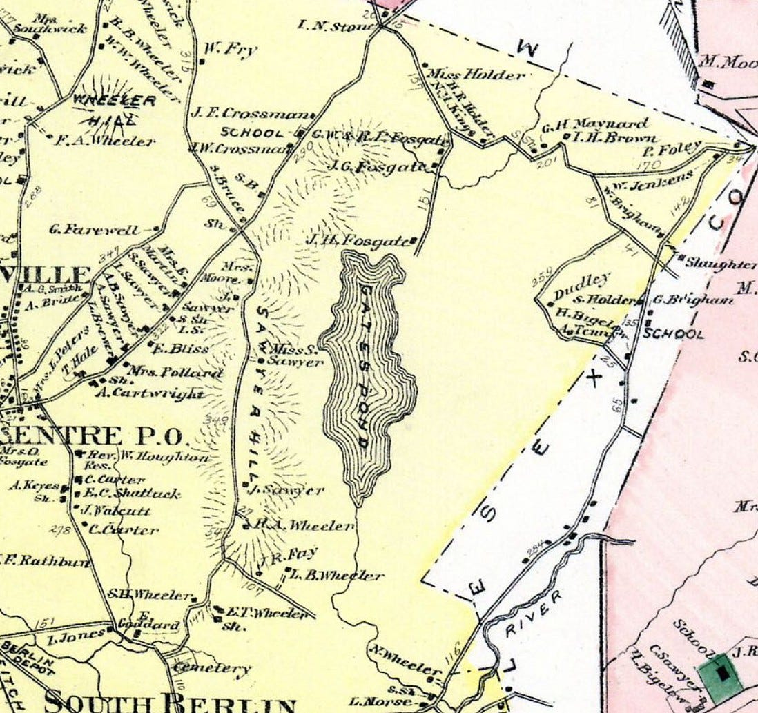
In 1717 the tract was set off to the Estate of Stephen Gates, an early settler of Lancaster (1654), though there’s no evidence he nor any of his heirs ever lived on the land. The Rev. Wm. A. Houghton, in his The History of Berlin - Worcester County, Massachusetts - from 1784 to 1895, writes, “the description of the land and the boundaries thereof, as contained in the original set off (included)… …a considerable part of a pond lying within the said land and bounded on all sides of it by common undivided land; a rock called the Sleeping rock is on the outside of it, near the northwest corner. The place where it Lyes by the Indians was called Kequasagansett, and is laid out to the estate of the said Stephen Gates for 314 acres.”
A few years later it was sold by Gates’ heirs to Robert Fosgate, Josiah Sawyer, and others. The Sawyer family came to dominate the western side of this little corner of Berlin, Massachusetts, the Fosgates, the east.
Houghton's History – completed and published by the town posthumously in 1895 - proved to be a great resource for the story of Gates Pond, albeit one whose contents required some sleuthing through given its curious organization — breakdowns into genealogical sketches of town families, rolls of those who served and died in the Civil War, Ecclesiastical history, Educational history, etc.
Gates Pond and Sawyer Hill in Berlin, Massachusetts were originally in the southeastern part of Nashaway, which then became Lancaster, site of raids and battles in King Philip's War in the mid-to-late 1600's. Bolton broke from Lancaster in 1738. Berlin later broke off from Bolton in 1784 to create an independent district. In 1812, Berlin officially became the town as it’s known today.
In the early 1600’s, many Indigenous Peoples in this region had died in a plague, a Great Dying. An unknown disease, likely transmitted to them by earlier European explorers and traders, swept through their populations just prior to the arrival of the Pilgrims in 1620.
They called this entire region Whipsuppenike, “the place of sudden death”, according to the City of Marlborough’s Historical Commission (The Lords of Whipsuppenike - History of Marlborough: https://www.marlborough-ma.gov/historical-commission/pages/lords-whipsuppenike).
As part of the early frontier, this region was the first arena where invading and indigenous cultures violently clashed. Despite this, and perhaps due to the Great Dying, many later settlers of Berlin came to believe Indigenous Peoples never lived in the territory comprising the town: “No records extent nor Indian relics point to the fact of any permanent lodgment within what is now Berlin territory,” Houghton wrote, reinforcing the all-too-common trope that Indigenous Peoples didn’t live in that place, they just passed through it, or fished or hunted there.
In contrast, Houghton noted that “Clamshell (Pond, in Clinton), as also Gates Pond, was nearly in a Direct Line between the Ockoocangansetts in Marlborough and Nashaways at Washacum, hence the trail leading from one place to the other would necessarily pass through this town and by these ponds.”
The Sawyer family were involved in two of the more notable historic interactions with Indigenous Peoples in the first half of the 18th century, one right around Gates Pond.
The first was an abduction amidst one of the early wars between colonists and the Indigenous Peoples. Three settlers were abducted who lived in the Gates Pond vicinity and "brought to Canada", including one Thomas Sawyer Jr, the grandson of early settler Josiah. During Queen Ann's War in October of 1705, Thomas, Jr., his son Elias, and John Bigelow of Marlborough were abducted from Thomas' saw-mill near the “Deer’s Horn.”.
The city of Marlborough’s online history mentions this incident among other abductions (though it gives prominence to Bigelow, the city resident) and reports, “there were many raids made here by Indians from the vicinity of Montreal, who would come down Lake Champlain and across Vermont and then strike easterly to annoy the English towns of Massachusetts. Marlborough was usually the place nearest to Boston to feel these raids...”
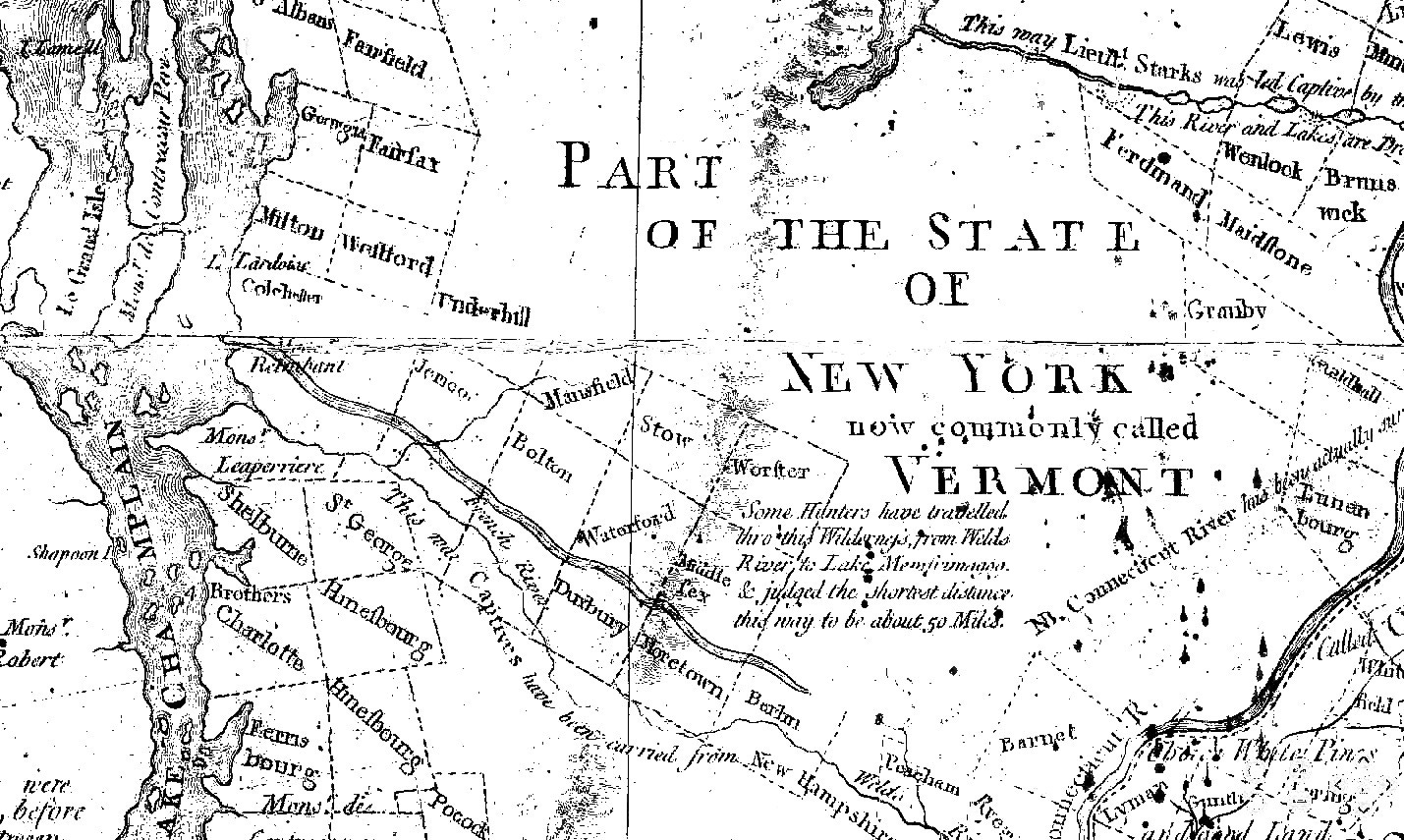
Captives like Bigelow and the Sawyers were likely brought up trails and along rivers like the Merrimack, the Connecticut, and the White. And, according to the Detail from a 1784 map of the “Province of New Hampshire” shared by historian Bob Blanchard on Facebook (created by Abel Sawyer for John Hancock, then-governor of Massachusetts, and for the “Honorable Council of the State of New Hampshire”), in the Burlington, Vermont area, "Indians" carried captives from the south (the Map says New Hampshire) along the Winooski River (The French River on the Map), which rolls along less than a mile from my present home on its way to Lake Champlain.

On a Saturday afternoon, I’d walked along the banks of the Winooski River near my home in Burlington, Vermont. I then headed to my old hometown of Hudson, Massachusetts on Sunday for a holiday visit, and on Tuesday and Wednesday, spent hours roaming around Gates Pond and Sawyer Hill in Berlin. As I then afterwards researched the pond’s history and read about this abduction, the resonances between their history and my reality shook me.
These men lived in the area where I once lived. They were abducted and brought up through the area where I live now, along paths I’ve followed for years, as I traveled between where I grew up and where I chose to live my adult life.
There is a certain resonance, as if I’m walking through history in these places, in experiencing these spaces. Learning the stories brings this history alive – it echoes around me, and, somehow, these areas now feel connected in a greater than personal way.
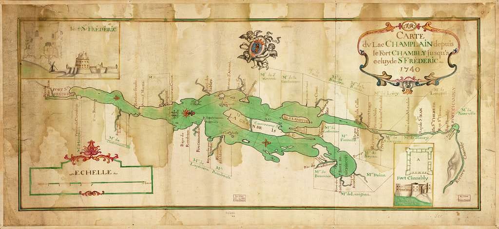
The men were taken up Lake Champlain, and then on up the Richelieu River. The Richelieu at the time was called the Chambly River or Iroquois River by Europeans, and Masoliantekw (‘water where there’s lots of food’) by the Abenaki. At Fort Chambly near Montreal, Thomas Sawyer Jr. negotiated for his freedom by agreeing to build Canada's first saw-mill, financed by Governour Claude de Ramezay of Montreal and Francois Hertel de LaFresniere, the Seigneur de Chambly.
It’s said the Indigenous Peoples, having freed Elias Sawyer and Bigelow, were loathe at first to let Thomas go, too, forcing local French officials to resort to trickery to get their “Christianized Indians” to cooperate. The Governour of Montreal and Father Theiry said they would unlock the gates of Purgatory with a giant key they brandished, and the Indians would be pulled in, unless they set Thomas free.
The Indigenous folks agreed to let the man go. The French authorities put the key away.
Sawyer built the sawmill, and he and Bigelow were freed to return home to Massachusetts, though his son Elias was forced to remain for an additional year to help run the mill. [Some additional details from “A French and Indian Wars Enigma” by Beatrice Couture Sawyer in Je Me Souviens -- A Publication of the American French Genealogical Society Vol. X, No. 1., Summer 1981.]
According to the Fort Chambly website, in the fall of 2011, when digging for a new project, they discovered the foundations of that first seigniorial mill at Fort Chambly, built by old Thomas Sawyer, Jr.
Sawyer and his progeny evidently were known for building mills, this misadventure seemingly adding to their renown. After relating the tale, Houghton exclaimed, “No wonder the Sawyers have had sawmill ‘on the brain’. If you can find a sawmill in all this region not started or run by a Sawyer, publish it!”
Houghton reported that Thomas Sawyer Jr.’s eldest son William Sawyer owned 100 acres of land on the West slope of Gates Hill, which is now Sawyer Hill, and 120 on the east slope. Also said to be on the hill were his sons William, Josiah, and Aholiab. It was this Josiah, later a Deacon, who was said to have been ambushed by an Indigenous Person and who made an amazing leap to escape. The town historian believed the family story: “The tradition of the Sawyer family of the remarkable leap of their ancestor here Deacon Josiah Sawyer, is undoubtedly substantially true, and worthy of record,” Houghton wrote.
According to the History, Deacon Josiah Sawyer became the owner of a tract of land on Sawyer Hill sometime around 1735. While clearing the land and making preparation to settle there, he was living in Bolton with his father. He was returning home one evening on foot, as was his custom, and:
“…in descending the hill just north of the Quaker Meeting-house, an Indian, in ambush by the wayside, sprang out with tomahawk in hand. Sawyer, being unprepared with defensive weapons, took to his heels, with the Indian after him. He, by his agility, outran the savage and reached his home in safety. By measurement the next day, it was found that one of the leaps, as the footprints showed, was sixteen feet, the most extraordinary leap ever known in these parts.”
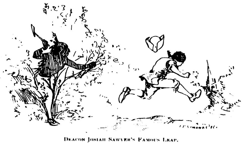
It's a good story. Maybe even true.
It struck me that the top of that slope, where the story begins, is where I found enormous stones and small boulders augmented and perched. And the climax of the tale, The Leap, down by the road, occurred near Sleeping Rock. Although, like the story of The Leap, I didn’t know about Sleeping Rock until later, after doing further research following up on my visits.
I did find an enormous boulder on that slope, but I don’t think it’s the Sleeping Rock, as it doesn’t look like the old black-and-white image. And if I’m understanding the descriptions correctly, it seems like Sleeping Rock should be a little further west, and closer to the road. I plan on returning to see if the original Sleeping Rock is still around.

Houghton:
“The rock South of the Hudson Rd, between Captain Silas Sawyer’s and George H. Bruce’s, has been known as Sleeping Rock from the early times, so named in some of the first deeds. The origin of the name appears to have been from the fact that Indians occasionally used it as a shelter and to sleep under, -- two were known so to do, says tradition. A shelving part has probably fallen over since that time. This rock was a corner of the original Gates farm. The place was called by the Indians the same as the name of the pond, Kequasagansett.”
An “Indian Stone” known as Sleeping Rock used as a marker in the earliest known deeds to this place once called Kequasagansett. A place the Indigenous Peoples just… passed through?
The Fosgates’ history on the land wasn’t quite as eventful as the Sawyers. The Fosgates lived on Gates farm starting in the 1750s. Lucas Fosgate joined the Shakers in the 1860s, and his sons divided up the old farm.
Grandson Frederick Fosgate ran the picnic grounds at Gates Pond and had several cottages on the Eastern Shore. That could have been a lucrative gig, for a time. According to Houghton, the pond was quite the place towards the end of the 19th century:
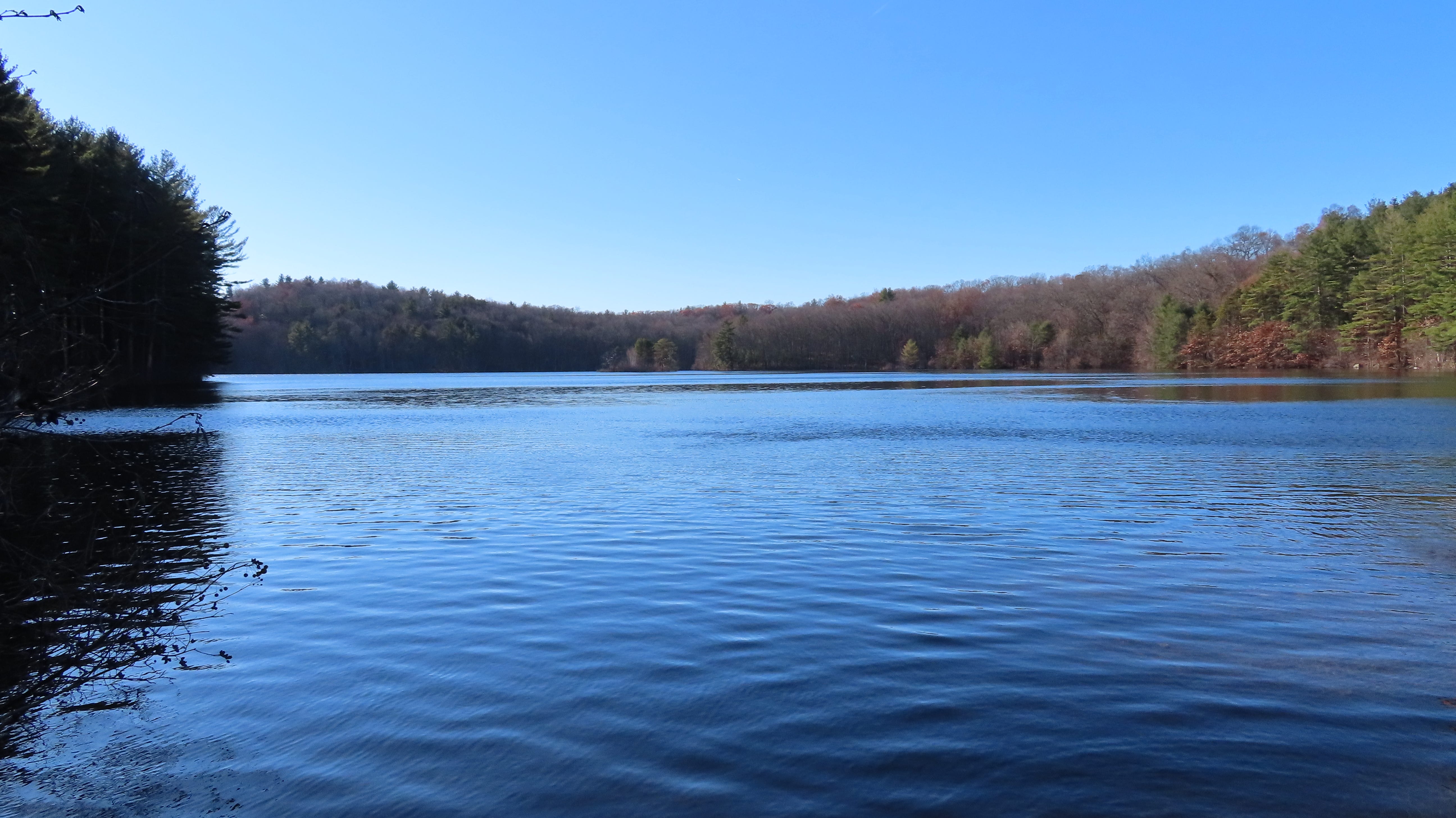
“This beautiful lake of pure, cold, crystal water, fed by springs, is the favorite resort of pleasure seekers and picnic parties in the summer season; the eastern shore is studded with cottages and houses for entertainment. On the western acclivity is Lake Side, so named by Madame Rudersdoff, the famous singer, who lived there a few years ago.”
That all changed. Hudson need a new water supply, and the town petitioned the Massachusetts legislature in 1883 to give Hudson eminent domain to take Gates Pond for a clean public water supply, which they did. The town took over the pond and its surroundings. Today, although Hudson primarily relies on wells for its public water supply, Gates Pond remains an auxiliary supply.
At the advice of the State Board of Health, Hudson eventually razed all buildings on the land surrounding the pond. In 1901, the Fosgates sued the town for damages, as the town’s taking of the water rights around Gates Pond stopped the water from flowing in two brooks across their pastures downstream.
Today, six lanes of superhighway Interstate 495 run through the old Gates Farm. The old Fosgate place is a world away from the pond, as Fosgate Road dead-ends at the other side of the highway. And Gates Pond Road no longer goes to Gates Pond.
Correction: Earlier versions of this story reported that the abduction of three men in 1705 took place just south of Gates Pond. I've been told this is incorrect, and that the abduction took place further north, in what is still Lancaster proper, near Four Ponds.